About the French Broad River Basin
The French Broad River, long considered to be one of the world’s oldest rivers, flows through an ancient landscape. Variably said to be between 265 million and 305 million years old, new evidence suggests the river may not be quite as old as the Appalachian Mountains which it traverses. Over the course of geological time the Appalachians have risen three times due to continental drift and collisions, and been weathered down from their peak of nearly 30,000 ft., to their current highest elevation of 6684 ft. at Mt. Mitchell. Due to its long evolutionary history and the varied terrain traversing five ecoregions1, the region is biologically very diverse. Numerous rare or endangered plants, mussels, amphibians, fish, and other animals live in the watershed2 having escaped most of the effects of the last ice age as it did not reach so far south. Over the past 100 years, their survival has become challenged by increasing human populations across the region, especially in larger towns and cities such as Maggie Valley, Hendersonville, Waynesville, and Asheville.
French Broad River Watershed Facts:
- Watershed encompasses 5,124 mi2 of land in North Carolina and Tennessee
- 72% of the area is forested
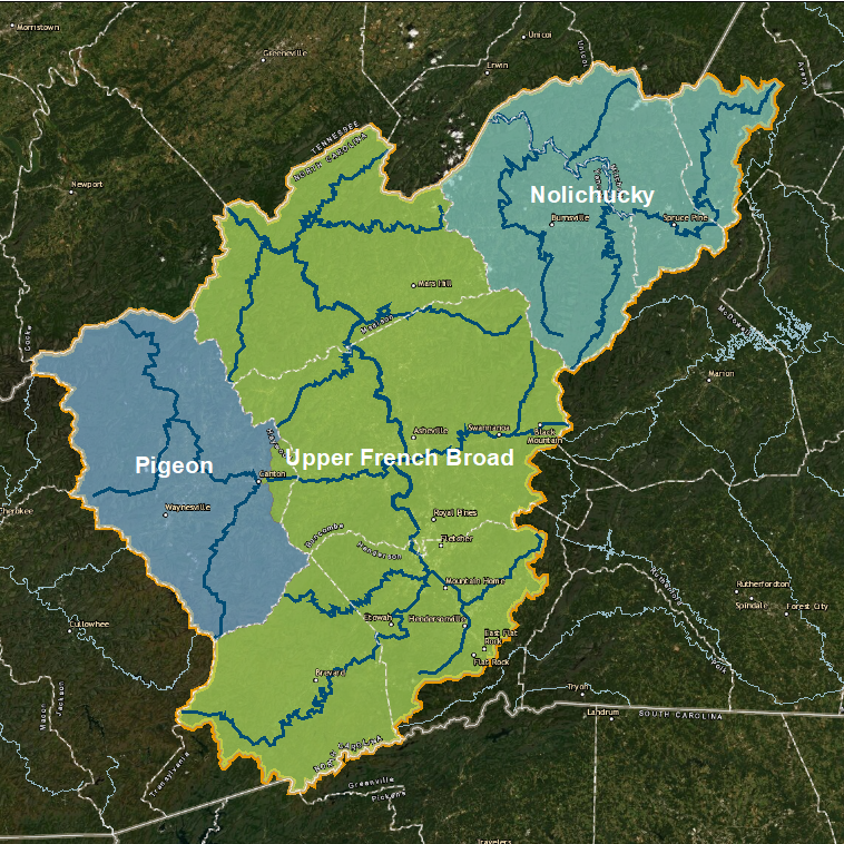
- Comprised of three major tributaries: Upper French Broad, Pigeon River, and Nolichucky River
- Upper French Broad
- Upper French Broad, western North Carolina’s longest river, originates at Courthouse Falls near the Town of Rosman in Transylvania County
- Flows through four counties: Transylvania, Henderson, Buncombe, and Madison
- French Broad River mainstem forms at the confluence of the Nolichucky and Pigeon rivers near Newport, Tennessee
- Pigeon River
- Arises in southeastern Haywood County south of Canton when the West and East forks merge, and flows northwest to its confluence with the Upper French Broad
- Nolichucky River
- Begins where North Toe and Cane rivers converge about 10 miles east of Tennessee border
- Major reservoirs in the basin include:
- Lake Julian
- Burnett Reservoir
- Beetree Reservoir
- Lake Kenilworth
- Lake Junaluska
- Allen Creek Reservoir
- Waterville (Walters) Lake
- East of Knoxville the French Broad River joins the Holston River to form the Tennessee River and eventually meet the Mississippi River
The U.S. Geological Survey identifies watersheds with codes called Hydrologic Unit Codes (HUC), for ease of reference among the thousands of river watersheds in the United States. The map above shows the three HUC 8 subbasins of the FBRB. You can open an interactive map, with more details, HERE as well.
Sub-basin Information
Upper French Broad River
(HUC #06010105)

- Watershed encompasses 1868 mi2, in Transylvania, Henderson, Buncombe, Madison Counties in NC, and Jefferson, Sevier and part of Cocke Counties in TN
- Area is home to about 600,000 residents (2020 projection including TN), whose largest cities are Asheville and Hendersonville
- Major industries are tourism, agriculture, and manufacturing
- Was significant degradation of the river by the 1950s largely due to manufacturing, but many pollutants were reduced below levels of concern as water quality regulations were implemented
- Sediment and bacteria remain significant concerns in many reaches of the Upper French Broad due to stormwater runoff, agricultural practices, and development
- Major tributaries are the Mills, Swannanoa, and Davidson Rivers
- Populations of the Federally endangered Appalachian Elktoe remain and are expanding in the Mills River, Little River, and portions of the Upper French Broad River
- Appalachian elktoe, once found throughout the mountains of western North Carolina, requires clean, well-oxygenated water that flows at a moderate to fast pace, stable gravelly or rocky bottom. (USFWS, 2008).

- Improving water quality in some reaches enabling Appalachian elktoe to expand range, an outcome of reducing sedimentation and other impacts that can impair our river
- The amphibian hellbender has lost much of its distribution due to habitat loss.
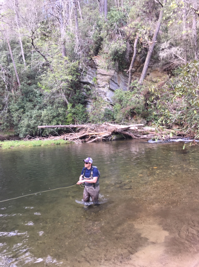
- Tributary is major tourism asset in Rosman, Brevard, Asheville, Marshall, Woodfin and other communities along its course
- Rafting and kayaking are common
- (References: NCWikipedia, Geology summary, NCDENR, USFWS)
Pigeon River

(HUC #06010106)
- 704 mi2 basin, arising in southeastern Haywood County and flows into Cocke County, TN
- Largest cities are Canton and Waynesville, population of 71,000 (2020 projection including TN)
- Flows 70 miles though Pisgah National Forest, Shining Rock Wilderness Area and adjacent to the Great Smoky Mountains National Park, from Canton, NC to Newport, TN where it joins the UFBR
- Main tributaries are Richland, Cataloochee, Fines and Big Creeks. Historically polluted by dioxins, elevated color, particulates, etc., from Champion papermill in Canton and other industrial sources
- Water quality now generally improved as result of efforts to modernize processes at the paper plant and coordinated cleanup by NCDEQ, EPA, Champion, and TDEC3 beginning in the 1990s
- Manufacturing still a significant sector in the region, along with fishing, rafting and kayaking enhanced by controlled releases from the Walters Dam
- Dam, completed in 1930 by the Phoenix Electric Company, provides electricity for communities and industry in region
- Upper Pigeon and West Fork still support populations of the Appalachian Elktoe
Nolichucky River
(HUC #01010608)
- Named for a Cherokee Village
- Westernmost subbasin of the French Broad River, formed by convergence of North Toe and Cane Rivers and contained in Avery, Mitchell, and Yancey Counties in NC, and Unicoi County in TN
- Name may mean “spruce tree place” in Cherokee, though there are other interpretations
- Flows 115 miles along some of highest peaks in the Appalachians, including Mt. Mitchell (highest peak east of the Mississippi River)
- Drains 1744 mi2 in NC and TN
- Regional population projected to be 87,000 in 2020 (including TN)
- Main industries are mining, manufacturing, tourism, and specialty tree cultivation.
- Davey Crockett born along its banks in Greene County, TN in 1786
- Region has steep elevations and forests that limit development, especially on NC side (Brittanica online, NC Wikipedia, USGS, County information)
Definitions
- Ecoregion—an area identified based on geology, soils, vegetation, climate, landuse and hydrology that establishes an ecosystem in which particular plants and animals can live (Omernik 1987, 1995). Different ecoregions have different types of trees, birds, fish, flowers, mammals, and other organisms. Examples include deserts, tropical broadleaf forests, temperate coniferous forests, tundra.
- Watershed—the land area that drains into a river
- TDEC—Tennessee Department of Environment and Conservation